Since first becoming enlightened about the practice of geoengineering and weather modification, (around 2011) I’ve been a frequent observer of the skies. Two days ago (24/25 February 2026) while viewing flightradar24, I spotted an NZAF aircraft flying from Rotorua up and around the East Cape. It finished a curious flight circling various areas, perfect circles, then continued on down across Napier then over to Sanson to land. This aircraft flew up and back two times from my observations, then possibly a third going by the historical replays. In addition I have observed three different USAF aircraft fly across that region, slightly inland, en route to and from Christchurch, one flying from Washington via Honolulu.
Note: You can track these planes yourself by registering free at one of the sites and watch the live view (I’ve only really used FlightRadar24). You’ll see all planes up at that time including the passenger airlines. The latter are also known to spray. If you click on the plane you will see its ID, destination etc etc to the left of the screen. If you record the number of the plane you can search later under replays (bottom of screen) and watch its other flights there. Free registration gives you 7 days replays however the paid option gives you longer. You can also search aircraft IDs which will indicate if they are currently in flight and where. Note though, many now are not supplying their ID and often where they are from or where they are going (indicated by N/A).
I’ve always kept an eye on the EBOP, East Cape, East Coast area over the years particularly because of a post I read (and republished) regarding their reserves of gas, oil and minerals and who wants them.
The region has of course been plagued with flooding which would seem to confirm the article is correct. At least to those of us who, like Australia's Sen Malcolm Roberts, do not believe the official narrative on climate change (and have educated themselves on the real reason it's changing).
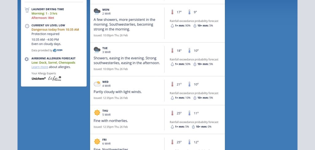
I’m posting what I’ve observed in the past two days. It seems possible to me that there is a flooding event imminent, going by the aircraft activity and the weather reports. (Rain currently forecast from Friday onwards, with a note that the falls could ‘exceed’ predictions. Even on forecast fine days!).
Note, I had captured extensive grid like flight patterns in several Nth Island bays and harbours, prior to the last flooding event earlier in February which affected the Waikato, (Otorohanga where one person died), Auckland and further down in the Rangitikei region. I’ll post those in a separate article which I was waiting to post anyway .... pre empted now by this.
Firstly though, to understand my speculations, read the following articles. The first includes some dot joining on aircraft and weather events. If you're already awake to geoengineering & with the topic of the East Coast reserves, you could skip straight to my observations:
The second is about the East Coast and plans they have for the area:
This last one, though not related to rain, it concerns a curious flight around the East Cape just prior to the first covid lockdown. Included because it illustrates that all is not what it seems in the skies:
Now to the past two days and the flight paths observed.
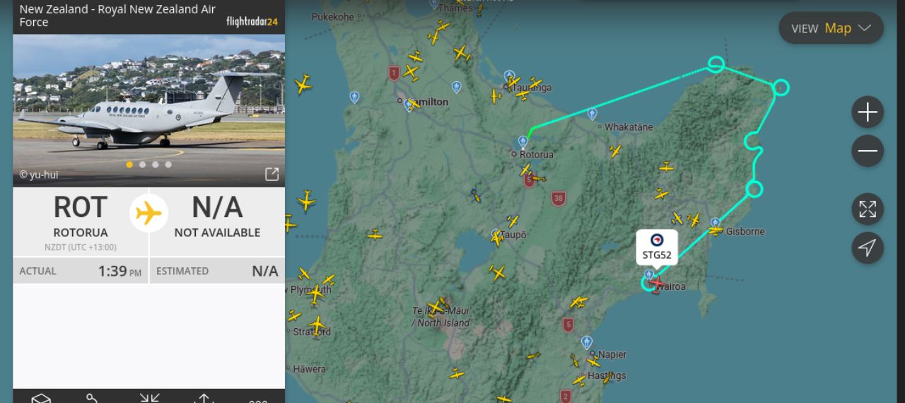
FIRST FLIGHT 24TH FEBRUARY 2026:

This was an NZAF aircraft. It circled at various places on its circuit around the East Cape down to Hawke’s Bay. It circled Te Puia Springs, Tolaga Bay, and at Wairoa it circled more than once before continuing on down. On Wed 25th February it circled there three times.
Wairoa has suffered greatly from flooding, was put in $40 million debt with their last major flooding, a debt which would have to be solved apparently by 50% rates rises due to there being no other avenue for help. The Mayor comments in an interview that next there will be nobody left in Wairoa.
23RD FEBRUARY 2026

This route, captured later on replay,
24TH FEBRUARY 2026

Clearly this flight was further inland, circling Lake Waikaremoana, Matawai, the area between Ruatoria and Tikitiki, Waihau Bay and Opotiki before landing at Rotorua. At the same time, a USAF C130 flies from Christchurch right over the same area of the East Coast heading north. There have been 3 of these over the past 3 days.

RETURN FLIGHT ON 25 FEBRUARY 2026:

This flight circled Cape Runaway, the area next to Te Araroa, Te Puia Springs & Tokomaru Bay, Tolaga Bay, Wairoa (3x) and returned to Sanson first crossing Napier.
26 FEBRUARY

This screenshot I captured today. It disappeared right after I captured it. Another NZAF aircraft that I have seen several times before. Not on this route though.
USAF AIRCRAFT

25.2.26

24.2.26

25.2.26
Suffice to say at this point, there has been three USAF aircraft fly twice over the East Coast region. And clearly from the activities of the NZAF planes, they are particularly interested in the circled regions. Their explanation may well be innocent however I personally doubt that. If you google explanations as I already did, they offer several.
There are many more screenshots I will add of other grid flying over these areas, in the hills and along the coastlines. I will add more including additional info as I'm able to but for now will leave you to draw your own conclusions and hopefully share the info.
If I were living in the East Coast regions I would certainly, as I frequently point out on this topic, plan escape routes etc and make emergency preparations. We are pretty much left to ourselves going by prior disasters of late. That is a whole other topic. Browse our coverage of other disasters and you will see. Particularly this one noted above. And this one. Matthew Short ex US military, rescued many from the floods and noted the corruption and sinister goings on during these events.
Finally, it is not my wish to scaremonger. It is simply to raise awareness. An ounce of prevention is better than a pound of cure. I hope that my speculations aren't correct. However we know 'their' aim is to own everything and for you to own nothing (and be happy of course). Any professions of sustainable practices etc etc are mere lipservice designed to fool you. Their practices are clearly the opposite of what they profess witness the pollution and destruction of the planet since their so called sustainable practices began. These disasters are just one of their means of acquiring land and property. Red stickers.
Read up on Agenda 21 and 2030 over at envirowatchnz.com. Main menu. Read our coverage of Cyclone Gabrielle, both here and at envirowatchnz. Use the search box.
Please do share this info, particularly if you know folk in the regions mentioned.
I will soon post the other info for further north and their recent flooding.
TWNZ
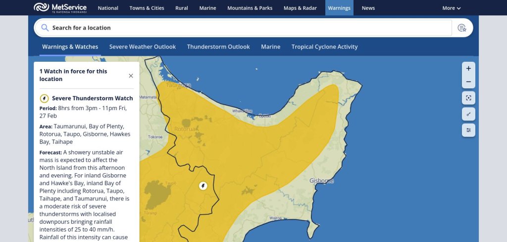
UPDATE 27/2/2026
Right on cue – weather warnings for these areas:
Below is a screenshot of Gisborne weather predictions. Note how even on fine days the prediction is a possibility of exceedance.